CicLAvia season is back for twennytwenny six, albeit later than usual. As you may or may not know, Metro, our county’s transportation provider which has graciously funded most of our CicLAvias for the past few years, is throttling down on our beloved open streets events in favor of transportation services for the 2026 World Cup and 2028 Olympics/Paralympics. This means fewer (and shorter) CicLAvias, unless we can do another fancy cross-promo with Netflix. Now this doesn’t mean the end of CicLAvias, we just won’t be enjoying the 8-CicLavias-A-Year-Aren’t-We-So-Spoiled schedule as of recent. Fortunately, we will have at least one more CicLAvia after this one; the 2nd CicLAvia of 2026 will be on Sunday, June 28 through South Los Angeles (Leimert Park and Exposition Park), which will be sponsored by Metro, and (E) and (K)-line accessible.
Sunday’s event – the first out of ? for 2026, and the 65th CicLAvia ever – (not sponsored by Metro, and thus not accessible by Metro Rail, though the closest station is the Metro (E) Line Expo/Bundy station, a mile south of the western terminus of the route) will take us on a totally new, 3-mile route through the Westside, visiting – for the first time – the communities of Westwood, Sawtelle and West Los Angeles.
Before we get to the guide, let’s do a little historical background!
What is now known as Westwood began as Rancho San Jose de Buenos Ayres, a 4,438-acre land grant given by Alta California governor Manuel Micheltorena to Maximo Alanis in 1843. It was vast prairie land with gentle rolling hills and creeks (remember this…). It was also suitable for farming, which was why John Wolfskill, Jr., whose father developed orchards and vineyards up north in Yolo (YOLO!) County and whose uncle William first hybridized and cultivated the Valencia orange, purchased the rancho in 1884 for agricultural use. In 1919 his heirs sold 400 acres of it to Arthur Letts, the founder of The Broadway department store, In 1924, silent film actor Harold Lloyd bought 25 acres of the old rancho for his new movie studio. Around the same time, the Janss Investment Corporation, who also purchased area land, planned a “Second Hollywood” west of the O.G. Tinseltown. A West Hollywood, if you will (what we know as WeHo today was still known as Sherman back then). But the Janss people wanted to portmanteau all dat so they called it Westwood. Meanwhile, the University of California Board of Regents, limited by already-developed parcels surrounding their rapidly growing University of California, Southern Branch campus on Vermont Avenue, decided to move the entire school to the vast prairie land with gentle rolling hills and creeks, and broke ground on a new campus…
The UCLA campus is vast and can warrant its own Epic Militant Guide! But in the interest of neutrality and anonymity (to obscure The Militant’s personal positive or negative bias towards this particular institute of higher learning), The Militant will not say any more on this school, other than if you really want to explore some hidden facets of the campus, check out this guide!
Meanwhile, a few miles west, just across the 405 Freew- (Oh wait, that wasn’t even built yet…) – is Sawtelle. Originally the Tongva/Gabrielino villlage of Kuruvungna (more on this later…), it became the 33,000-acre Mexican land grant of Rancho San Vicente y Santa Monica, given by Alta California governor Juan Bautista Alvarado to Francisco Sepulveda II in 1839. In 1896, the Pacific Land Company purchased 225 acres of the former rancho to develop a new town, named after the company’s manager, William E. Sawtelle. In the 1890s, immigrants from Japan settled here (more on this later). After much back and forth, including an annexation vote and an attempted civic coup, the town of Sawtelle was assimilated the City of Los Angeles borg in 1922. The neighborhood of Sawtelle even has its own street gang, the phonetically-named Sotel 13. Wouldn’t ol’ William himself be flattered by that legacy?
If you’re familiar with The Militant’s Epic CicLAvia Tour guide, which is meant to deepen the appreciation of each community CicLAvia goes through, you know The Militant has prepared each of them prior to every CicLAvia so that you can visit any of these points of interest yourself during CicLAvia Sunday. As usual – Go Dodgers, Go Lakers, Go Kings Go, Go LAFC or Galaxy and see you or not see you on the streets this Sunday!
Oh yeah, if you found this Epic CicLAvia Tour guide useful and visit any of these sites, please add the #EpicCicLAviaTour hashtag to any social media post that includes it. The Militant will be glad to re-tweet!
And if you appreciate The Militant’s work, kick him a little love via PayPal! He *hates* asking for money, but you know how it is these days…A Militant’s gotta pay his bills! He sacrifices a lot of his time to do this, so your support is much appreciated!
To support The Militant Angeleno: https://www.paypal.com/donate/?hosted_button_id=K5XC5AM9G33K8
1a. The Lost Creeks of UCLA – Stone Canyon Creek
1929
near Charles E. Young Drive North and Westwood Plaza, UCLA Campus
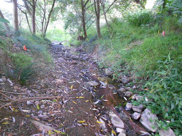
In August 2011, The Militant wrote about The Lost Creeks of the UCLA campus, in which there were once four very visible creeks running through the university’s campus in its early days before being channelized and buried as the school grew: West Arroyo, Foothill Stream, East Arroyo (more on this later) and Stone Canyon Creek. All four of those creeks run down from the Santa Monica Mountains and are a part of the Ballona Creek watershed. Stone Canyon Creek is the only one still visible to this day, running from its namesake canyon up above Bel-Air, paralleling its namesake road before crossing under Sunset Boulevard in an underground culvert and emerging for about 1200 feet through Bruinland between the UCLA Lab School and the Anderson School of Management. It then enters an underground channel and runs under campus and under Gayley Avenue where it empties into Ballona Creek near Mar Vista. In 2008, thanks to the efforts of The Bay Foundation and UCLA volunteers, the creek bed was restored with California native plants (YESSSS!), benefiting the natural biodiversity of the creek. You can see Stone Canyon Creek flowing with your own eyes by going to the north part of campus, just behind the Anderson School and the Collins Center.
1b. The Lost Creeks of UCLA – Arroyo Bridge
1927
Dickson Court within Portola Plaza, UCLA Campus
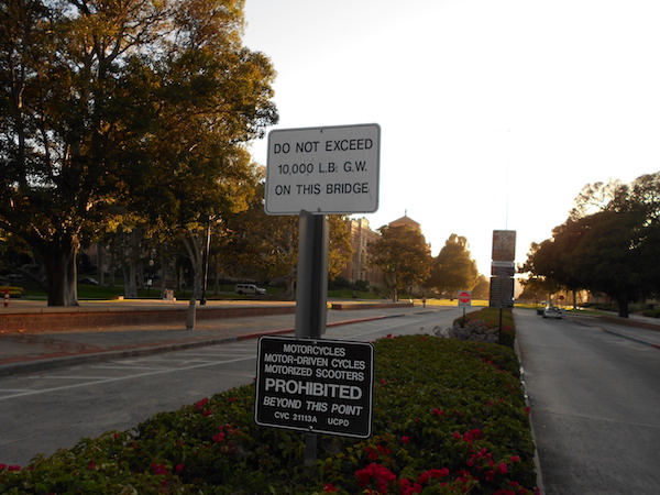
Cutting deep though the east side of the UCLA, paralleling Hilgard Avenue was East Arroyo, the most prominent geological feature of the Westwood campus back in its early days. The very first structure completed on campus in 1927 was a 285 foot-long Roman aqueduct-inspired bridge along Dickson Court spanning the arroyo, designed by the campus’ main architect George W. Kelham, offering the main entrance to UCLA from its east side. In 1947, faced with an increasing student body and the need to construct new buildings, the creek’s ravine was filled in, leaving the once-picturesque bridge now looking like a low brick wall. But alas, it is still considered a bridge to this day, requiring regular inspections and with a weight limit, as indicated by a sign that reads, “DO NOT EXCEED 10,000 L.B. G.W. [gross weight] ON THIS BRIDGE”
2. Westwood Village
1929
Between the UCLA Campus and Wilshire Blvd, Westwood
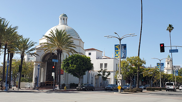
The main commercial center serving UCLA owes its existence to the Janss Investment Corporation, a family-owned real estate development company that lasted for 100 years and spanned four generations. Founded by family patriarch Peter Janss, a Danish immigrant, his company developed residential subdivisions in East Los Angeles, Boyle Heights, Monterey Park and Yorba Linda. Peter’s son Harold married Gladys Letts, the daughter of Arthur Letts (remember that dude?). After Mr. Letts passed away in 1923, his daughter and son-in-law inherited his old Wolfskill Ranch properties and Harold Janss and his brother Erwin sold 385 acres to the University of California in 1924, and the rest is history. In the late 1920s, the Janss brothers developed 55 acres south of the university as a Mediterranean/Spanish Revival-themed retail and entertainment district, replete with cinemas, department stores, supermarkets and restaurants, catering to both the student body and the upscale residents of the surrounding neighborhoods (which they also developed). The Janss Investment Company was one of the largest proponents and beneficiaries of racial covenants, which purposely kept away people of color from their residential and commercial developments (although the more recent generations of the Janss family had made efforts to atone for the actions of their forebears by supporting social justice and human rights organizations). Westwood Village also features notable buildings such as the Moorish-inspired Janss Dome building (pictured – once the headquarters of JIC), the Spanish Revival/Moderne Fox Theater and the Art Deco Bruin Theater. Once considered one of the prime entertainment/cultural hotspots of Los Angeles until the mid-1980s, Westwood Village hopes to see a revival come 2028 when Metro’s Westwood/UCLA (D) Line subway station opens.
3. Pierce Brothers Westwood Memorial Park
c. 1880s
1218 Glendon Ave, Westwood
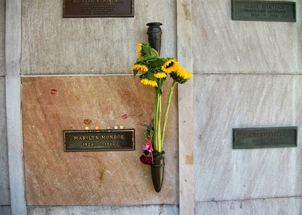
Nestled low-key behind the IPIC Westwood theatres (formerly known as the AVCO Cinemas) is the (non-)living embodiment of celebrity (after-)lifestyle: Westwood Memorial Park. Originally an informal cemetery in the 1880s, it was formally incorporated in 1905 as Sunset Cemetery, and in 1926 – yep, 100 years ago – it was re-named Westwood Memorial Park. It is the eternal resting place for such Hollywood luminaries as Kirk Douglas, Burt Lancaster, Dean Martin, Natalie Wood, Hugh Hefner, Farrah Fawcett, Armand Hammer, Frank Zappa, Beach Boy brothers Brian and Carl Wilson, as well as countless others. But without a doubt, the most famous forever resident here is Marilyn Monroe (whose mausoleum niche can be found towards the northeast corner of the cemetery).
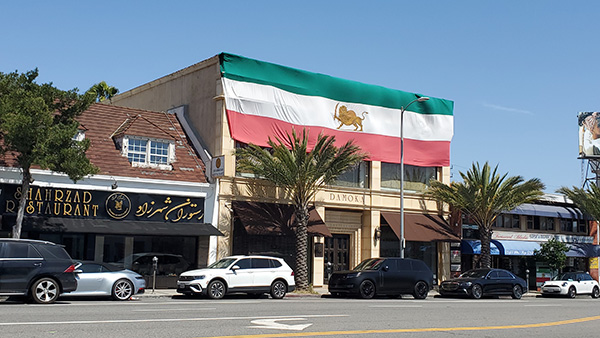
4. Persian Square/Tehrangeles
1974
Westwood Blvd and Wilkins Ave, Westwood
Here’s the scoop, literally: In 1974, entrepreneur Ali “Haji” Kashani-Rafye founded Saffron & Rose, an ice cream shop featuring flavors from his native Iran at 1387 Westwood Boulevard. That in turn inspired other Iranian businesses to join Haji’s humble ice cream shop up and down the boulevard. The 1979 Iranian Revolution caused a surge in immigration, with most settling in Los Angeles’ Westside communities. Today, that area, informally known as “Tehrangeles” (because who doesn’t love a great portmanteau?), is home to around half a million residents of Iranian/Persian descent and is the largest Iranian community outside of Iran. In 2010, the intersection where the community anchor Saffron & Rose Ice Cream is located was designated as “Persian Square” (because who doesn’t love a great pun?). The Iranian community has been…going through some stuff lately, so if you wanna show some love (and partake in some great eats as well), do also check out the legendary Shamshiri Grill (1712 Westwood Blvd), Taste of Tehran (1915 Westwood Blvd), Farsi Cafe (1916 Westwood Blvd) and Pink Orchid Bakery and Cafe (1927 Westwood Blvd).
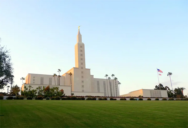
5. Los Angeles California Mormon Temple
1956
10777 Santa Monica Blvd, Westwood
In the 1930s, Harold Lloyd closed down his motion picture studio, subdivided his property and sold it to various institutions, such as the Los Angeles City School District, which built the Richard Neutra-designed Ralph Waldo Emerson Junior High School on the west end; the Archdiocese of Los Angeles, which built St. Paul the Apostle Catholic Church on the north end; and the Church of Jesus Christ of Latter-Day Saints, which planned to build its Los Angeles Temple on 13 acres of the south end. Nearly 20 years later (delayed by World War II and fundraising), what was then the world’s largest Mormon temple was dedicated (now the largest outside of Salt Lake City). It was also the first LDS temple built in California and stands 257 feet with a spire topped by a statue of the angel Moroni.
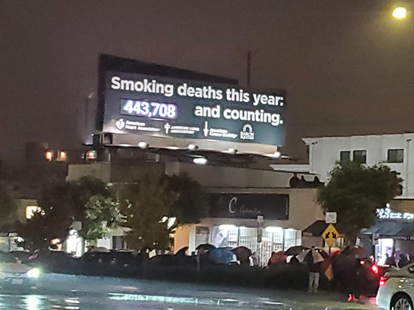
6. Smoking Deaths Billboard
1987
10948 Santa Monica Blvd, Westwood
Bill Bloomfield, a Los Angeles native (University High alum) and local small businessman kicked his smoking habit in the 1980s and together with his father, decided to finance a billboard along Santa Monica Boulevard at Veteran Avenue in 1987 displaying the tally of U.S. deaths attributed to smoking, as public awareness highlighting the dangers of smoking, as well as the negative influence of Big Tobacco. The count is shown on a computer-controlled six-digit display that shows an estimate of smoking deaths, which average a little less than one per minute. For over a decade, crowds (which have grown exponentially in recent years) have gathered in front of the billboard each New Year’s eve (some ironically or unironically smoking themselves) to “count down the New Year” and watch the display reset to zero at the stroke of midnight. The Militant was just there – along with around 700 Angelenos – this past New Year’s Eve to usher in 2026 (the 2025 count maxed at 443,731).
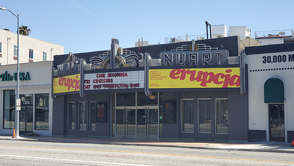
7. Landmark Nuart Theatre
1930
11272 Santa Monica Blvd, Sawtelle
Opened in 1930 by Forest McManus, who also owned Santa Monica’s Tivoli Theatre (now Laemmle’s Royal Theatre), the originally 660-seat, single screen cinema featured motion pictures as well as live stage shows. In 1932 the Nuart changed hands to new owners Scotty Bayliss and George Bourke, who updated its marquee to a colorful Art Deco-style getup. In 1974 the Landmark Theatres chain bought the Nuart and made it its, well…landmark theatre, specializing in independent, foreign-language and arthouse features, which has been its niche ever since. In 1976, the theatre first screened the cult classic, The Rocky Horror Picture Show and in 1986, Nuart started presenting the film in its popular interactive Saturday night midnight screening format, which continues to this very day, 40 years later. Unfortunately, the grand Art Deco marquee is no more, as it was replaced in 2006 after a renovation of the theater, which also reduced its capacity to 303 seats.
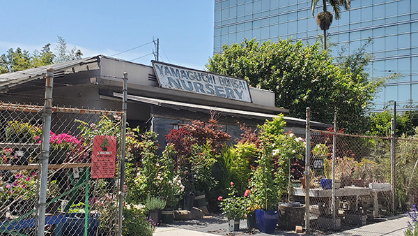
8. Sawtelle Japantown
c. 1890s; Designated 2015
Sawtelle Blvd between Ohio Ave and Olympic Blvd, Sawtelle
Japanese immigrants began arriving in what was then the city of Sawtelle in the 1890s due discriminatory racial covenants that prevented them from owning property in the City of Los Angeles, though no covenants existed in adjacent Sawtelle. They were able to remain when Sawtelle was annexed by Los Angeles in 1922 and the area was known for its nurseries and garden centers — over two dozen Japanese-owned nurseries were operating in the Sawtelle area in the early 1940s. But World War II and Executive Order 9066 forced the Japanese American community out of their homes until the war ended four years later. Today, Sawtelle (a.k.a. Little Osaka) offers a somewhat lower-density, laid-back counterpart to DTLA’s Little Tokyo, home to traditional Japanese-owned businesses like Hashimoto Nursery (since 1928) and Hide Sushi (1979), as well as newer Asian American-owned establishments along the boulevard catering to younger generations. In 2015, the district was officially designated as Sawtelle Japantown by the City of Los Angeles.
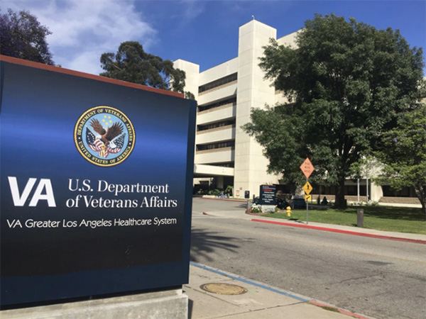
9. VA Los Angeles
1888
11301 Wilshire Blvd, Sawtelle
What we know today as “The VA” began in 1888 as [takes deep breath] the Pacific Branch of the National Home for Disabled Volunteer Soldiers, commonly known as the Sawtelle Veterans Home on 300 acres of land donated by former US Senator John P. Jones Col. Robert Symington Baker and his wife, Californio socialite Arcadia Bandini de Baker (Ever heard of Bandini Blvd? Yeah, that was named after her…) as a facility to care for disabled Civil War veterans. In 1927, the newly-created Veterans Bureau opened the James W. Wadsworth Hospital to care for World War I veterans and to replace the old Soldiers Home hospital. In 1930, President Herbert Hoover merged the National Home and Veterans Bureau to create the United States Veterans Administration (now Veterans Affairs), which ran the facility. Today’s VA Hospital complex was built in 1977 to care for the needs of Vietnam War veterans. The VA complex has also influenced the naming of many local streets: Did you know that the streets National Boulevard, Federal Avenue, Westgate Avenue and Military Avenue were all named because of their relationship to the Soldiers Home? From 1908 to 1920 the Soldiers Home was even served by its own Pacific Electric line (the original depot structure still exists, although it was moved to a new location of the VA north of Wilshire Boulevard). But come 2028, you can visit the VA complex by rail once again thanks to the Metro (D) Line Westwood/VA Hospital station near Wilshire Boulevard.
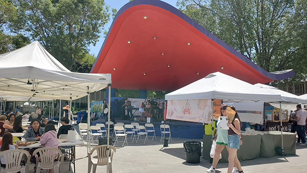
10. West Los Angeles Civic Center
1957
1645 Corinth Avenue, Sawtelle
Though Los Angeles as a human settlement has been around since 1781, and has been an incorporated American city since 1850, the modern city you see today – for both better and worse – was defined in 1949 when a Master Plan for Branch Administrative Centers was devised in the postwar era to decentralize City Government institutions and create 12 mini “civic centers” spread around the city.
One such branch administrative center, the West Los Angeles Civic Center was built between 1957 and 1965 and contained a municipal courthouse, a city council field office, a Los Angeles Public Library branch and a community center. WLACC’s buildings were designed, like many in its time, in the Mid Century Modern style by the firm Allison & Rible (which also designed the Los Angeles County Arboretum) and by Albert Criz (who designed Mar Vista Gardens). Today (like, literally on CicLAvia Sunday), the WLACC is also home to the West Los Angeles Farmers’ Market, open every Sunday from 9 a.m. to 2 p.m. There is currently a proposal to replace the entire WLACC with a new, high-density mixed-use project known as West LA Commons.
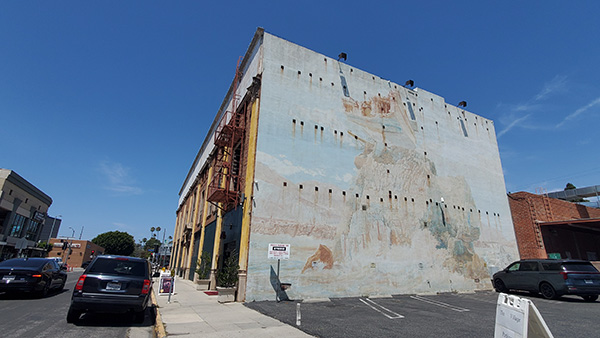
11. The Village Studios
1968 (building built 1922)
1616 Butler Avenue, Sawtelle
In 1968, musician and composer Geordie Hormel (grandson of meatpacking tycoon George Hormel) did what any musically-inclined nepo baby would do: Buy a former 1922 Masonic Temple off of Santa Monica Boulevard and turn it into a recording studio. There, in its sacred halls and soundproofed walls was recorded some of the most iconic albums in rock history, such as Fleetwood Mac’s Tusk, Supertramp’s Breakfast In America, The Jacksons’ Victory and many of Steely Dan’s albums in their discography as well as Donald Fagen’s solo debut The Nightfly. Even Gwen Stefani’s Love Angel Music Baby was recorded here. The studio even includes a Steingway grand piano once owned by jazz musician Oscar Peterson. The studio is also a popular location for recording motion picture and television show soundtracks. Though most of us can’t go inside, the southern wall is also home to the classic 1972 (hence somewhat sun-faded) L.A. Fine Arts Squad mural, Isle of California.
12. Kuruvungna Village Springs
c. 400 B.C.
1439 S. Barrington Avenue, West Los Angeles
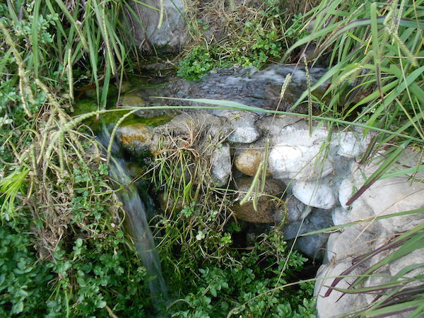
On the southeast corner of the University High School (more on this later) campus is a place where water still naturally flows from the Earth. The Tongva village of Kuruvungna (“Our place in the sun”) once stood here, where its inhabitants were hydrated by at least three known flowing springs. In 1769, the Gaspar de Portola expedition, while trekking along what is now the 405, stopped by the springs and had a peaceful encounter with the indigenous villagers. Though many attribute Fr. Juan Crespi, one of the clergymen who accompanied Portola, to contributing to the etymology of the city of Santa Monica (supposedly he described in his well-documented journal that the cascading springs flowed like the tears of St. Monica, though no entry in his journal actually mentions that), the “tears of St. Monica” description wasn’t known to be documented until the early 1800s, some 20 years after Crespi’s death (The Militant has known that history can get messy…). There are two springs that art active today: One at the Kuruvungna village site, which flows into a small lagoon, and another in the middle of the Uni High campus, next to the grass terrace at the north end of the baseball fields. Together the springs produce some 25,000 gallons of water daily and was once used as part of the City of Santa Monica’s municipal water supply. The Kuruvungna site, considered sacred by today’s Tongva/Gabrielino peoples, is mostly closed off, but is open to the public on the first Saturday of the month from 10 a.m. to 3 p.m., where free guided tours of the village are given, and the site also hosts a Tongva Festival every September. The Militant explored the springs himself back in 2011!
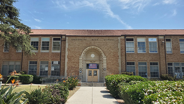
13. University High School
1924
11800 Texas Avenue, West Los Angeles
Built over a century ago to serve the newly-expanding City of Los Angeles’ western frontier, Uni High opened in 1924 as Warren G. Harding High School, in honor of the once-popular US president who died the year before. But as various post-mortem scandals surfaced (apparently this Warren G. was also known to regulate…), the school changed its name to University High School, to reflect both its proximity to the newly-opened University of California Los Angeles, and its connection to UCLA as its School of Education students were known to have worked as teacher’s assistants at the high school. Uni also boasts a large number of famous alums such as Jeff Bridges, Judy Garland, Danny Elfman, Randy Newman, members of The Doors and Tone Loc. Go Wildcats!
14. Ohio and Bundy Triangle Park
1928
Convergence of Bundy Dr, Santa Monica Blvd and Ohio Ave
In 1928, as the nascent neighborhood of West Los Angeles grew, the City of Los Angeles wanted to connect Santa Monica’s Broadway corridor with its Ohio Avenue by cutting through the former Amling Nursery property, thus creating an extension of Ohio Avenue between Centinela Avenue and Santa Monica Boulevard (a.k.a. Route 66). The new street alignment created a triangle which was naturally envisioned as a public mini-park. A grassy area with granite walkways and wooden benches was built as a result, creating a public space for area residents. There were even more grandiose plans for the park, such as erecting a monument on the site, lining it with Italian Cypress trees, creating a ornamental pool, a public restroom (yeah, no, there ain’t enough room in the park for alla dat) and an underground pedestrian tunnel so residents on the north side won’t have to deal with autos and Pacific Electric streetcars. But alas, they were never built and the park remained in its relatively modest state. In the 2010s, in order to address local residents’ and businesses’ concerns about homeless individuals setting up encampments in the park, the City erected tall steel fences, enclosing the once-accessible public space. In 2025, the seasonal Bundy Triangle Night Market was established on the Ohio Avenue section of the triangle, which happens every Friday night from 5 to 9 p.m. between late March and late October.
You must be logged in to post a comment.