DAY 3: WEDNESDAY, MARCH 6, 2024
The Militant woke up to a cool (45ºF) but mostly sunny morning in Chillville, USA (a.k.a. Lone Pine, CA). Mt. Whitney and the rest of the southern Sierra crest smiled down upon him. He took a walk around town for some breakfast, this time up Main Street a little bit to a cozy place called Lone Star Bistro (the Texophile name seemed off-putting at first until he realized it was the “star” of “Lone” Pine or thereabouts), where The Militant partook in a coffee and a breakfast sammich to start the day, both of which seemed pretty affordable. The rest of the eatery also sold Eastern Sierra-centric souvenir clothing and merch, and there was a neato patio for outdoor dining, though he preferred the warmth of the interior this morning.
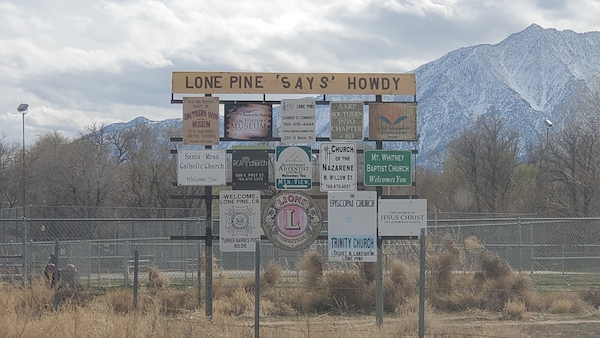
He walked up Main Street, past Jake’s Saloon where he found a single supermarket – Lone Pine Market, a place that sold the essentials, plus a very thorough snack section and an impressive beer corridor. Overhearing how the locals interacted here made him feel like he really was in the kind of small town where chit-chat became local news and gossip. Towards the northern end of the town, past the Carl’s Jr. was Spainhower Park, named after Russell Spainhower (1890-1957), a local who specialized in horses, mules and wagons and was the point-person for the Western movie filming crews’ equestrian needs. There was a creek running through the center of the park, it added to the rustic serenity of Chillville. Across the street was an ice cream place called Frosty Chalet, which was unfortunately closed for the season (the concept of seasonal business schedules is a rather strange and exotic concept for this urban Militant). He also happened on this Lone Pine welcome sign for southbound travelers, which had…uhh…questionable grammar:
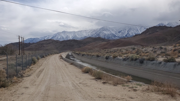
After his pedestrian tour of the town, he checked out of Dow Villa Motel. On his way out of town he wanted to briefly check out the Los Angeles Aqueduct and the famed Alabama Hills – It was only a half mile up Whitney Portal Road where he finally laid his eyes upon the Aqueduct in non-enclosed pipe, non-crazy fun water slide form, with a dirt service road running parallel to it. It was a strange juxtaposition – this serene, near-silent serenity below the snowcapped Sierra just on the outskirts of Lone Pine, with a loud gash of 20th-century infrastructure running right through it, with water flowing steadily southward into our faucets. It made the Militant feel simultaneous emotions of both awe and awkwardness.
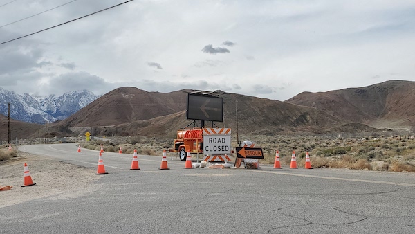
Unfortunately, The Militant was only going 1 for 2 as Whitney Portal Road to the Alabama hills was closed due to flood damage from last Summer’s Tropical Storm Hilary. There were signs for a detour but it involved going south on 395 for a few miles and then taking another road into the hills, which was the opposite direction The Militant was heading. Maybe on his way back or a future visit he might get to hit Them Thar Hills.
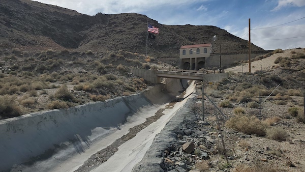
Oh well, time to head north along 395 to his next stop, the town of Independence. But not before catching another Aqueduct Feature – the Alabama Gates, just a couple miles north of Lone Pine. This water diversion facility allows excess water from the Aqueduct during storms or high snowmelt seasons to spill into a channel that flows into the Lower Owens River and end up where the water was long meant to belong – into Owens Lake. Apparently there was a lot of that going on last year. This was also the spot where, in 1976, a local teenager named Mark Berry blew up part of the structure. In a twist of irony, the teenabomber grew up and got a job with the DWP.
THE MILITANT’S MANZANAR MEMOIR
Heading north along 395 (for some reason it sounds more natural for this native Angeleno to say “395” and not “the 395” since US 395 is technically not a freeway per se), just 10 miles north of Lone Pine is Manzanar National Historic Site, one of the ten “War Relocation Centers” that Japanese Americans were forced to live in during World War II. Many Japanese American Angelenos who lived in Little Tokyo and the Eastside were taken to Manzanar, but although it was the closest such camp to Southern California, not all Southern Californians of Japanese descent were sent here.
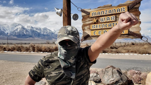
The Militant has heard about Manzanar many times from his visits to the Japanese American National Museum in Little Tokyo, which has had various Manzanar/internment camp-related exhibitions over the years, but it’s another thing entirely to actually be here. During World War II, as many as 10,000 people were incarcerated at Manzanar, making it the largest human settlement ever established in the Owens Valley.
A former apple orchard (hence the name), the land was once owned by the DWP as part of its Aqueduct water rights properties. They leased the land to the U.S. Department of War (now Defense) during WWII, but now the property belongs to the National Park Service since its establishment as a National Historic Site in 1992. It is also a designated City of Los Angeles’ Historic-Cultural Monument (No. 160) as well as a California Historic Landmark (No. 850).
Today was a Wednesday and unfortunately the visitor center/museum was closed to the public. But the grounds were open to the public for self-guided tours. There were re-constructed barracks that showed the living and dining conditions for those that were sent here, the most stark were the “latrines” which had open public toilets and showers with zero privacy inside. Ack!
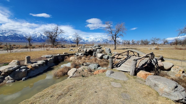
But there were areas of beauty and respite here, such as the various gardens and parks built in the camp, featuring streams and koi ponds with wood and stone bridges and footpaths, as many Japanese Americans at the time held jobs as gardeners, landscapers or ran plant nurseries before the war. Some of the gardens were restored just a decade ago, but a few of them suffered damage from flash flood resulting from Tropical Storm Hilary last year. This is one of the picturesque parks, which was either spared from the floods or cleaned up just in time:
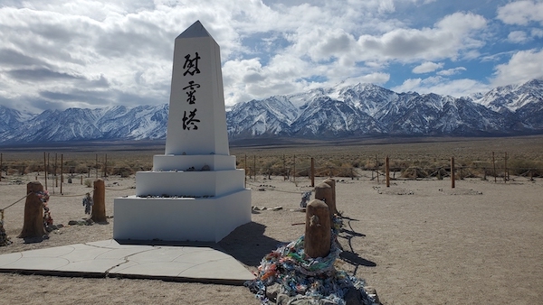
At the far west end of Manzanar, set to the imposing, majestic, snow-covered backdrop of Mt. Williamson (the 2nd-tallest mountain in California) and the rest of the Sierra Nevada mountains was the cemetery, marked by an obelisk called the Soul Consoling Tower, perhaps the most iconic landmark within Manzanar. It is were those who died during their time at the camp were buried (although the majority of them were moved elsewhere after the war), but it remains a sacred, solemn site. It is also here each April where the annual Manzanar Pilgramage takes place, where surviving incarcerees, their families and others – most of whom come up from Southern California – have a community reunion and daylong program reflecting on the meaning of the site, especially as an educational experience for younger generations.
Hearing only the sound of the wind, The Militant was indeed able to find peace and consolation here.
Heading out, The Militant saw that there were some park ranger staff walking the grounds. One of them was actually from Los Angeles and after learning of The Militant’s origins, let him inside the visitor’s center briefly (The Militant was not aware his militant perks were still valid this far from home)! The visitor center is a museum/interpretive center with various exhibits pertaining to the conditions that led to the establishment of the internment camps, as well as glimpses of life here, a scale model of Manzanar and a list of the 10,000 that lived here. The Militant once had a co-worker whose grandparents were sent here and he was able to see their names on that list.
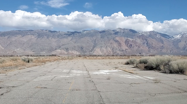
After The Militant said his own Farewell to Manzanar, he crossed 395 and headed due east along Manzanar Reward Road, just to go full-on Huell Howser and find an obscure hidden nugget of California Gold. It is here that lies an abandoned airstrip known as Mananar Airport, where the U.S. military landed planes (though it was not operationally related to the camp). The runways were decommissioned after the war, hence the large “X” marks along the runways to inform active pilots of a deactivated runway.
AQUEDUCT, PART DEUX
Just five miles up the road, some 15 miles north of Lone Pine (the same distance between Santa Monica and Downtown Los Angeles, though it doesn’t feel nearly as far at all) is the town of Independence, the seat of Inyo County, which is home to a whopping 669 people. But this place has a ton of history, and The Militant is all about dat, so that’s why he picked it as his next base of operations.
Before heading into town proper, The Militant wanted to check out some more Aqueduct features, so he veered east on Mazourka Canyon Road, which basically let to seemingly nowhere. It was then when he started to encounter (en-cow-nter?) some of the locals:
The Militant doesn’t feel comfortable with the way the locals are looking at him…#IndependenceCA #OwensValley #EasternSierra #MilitantRoadTrip pic.twitter.com/ShGwr2K7vn
— Militant Angeleno (@militantangleno) March 7, 2024
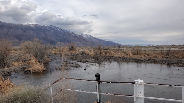
He did get to cross over another section of the Aqueduct, but the real site was further down the road. And there it was, the actual Owens River – well, technically, according to its colonial resource masters, The Lower Owens River Project (LORP), a restoration of the lower Owens River by the DWP (under pressure by the locals) started in 2006 to add just enough water to make it more amenable to recreation and ecosystem support. And this is what it looks like, maybe not that pretty, but at least there’s some water:
DECLARING INDEPENDENCE
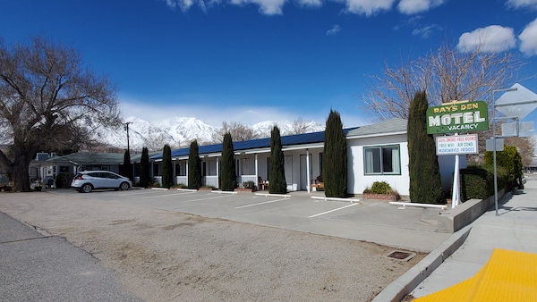
The Militant checked into his new lodging quarters in Independence, this time Ray’s Den Motel, on the northern edge of town, also along 395 (which is called Edwards Street here). Run by a friendly woman named Linda, she informed The Militant Visitor from That Big City Down South that the original owner of the motel, Raymond Denn (get it?) was a contractor from Glendale who built his sorta-eponymous inn (cool-ass neon sign and everything) in 1949. This place seems to love its history, The Militant digs it!
After getting settled in his room, he put his combat boots back on and decided to take a stroll around town (which only takes like 10 minutes to walk through). If Lone Pine was Chillville, Independence makes it look like Pasadena in comparison.
Independence, California was founded back in the 1860s, going under various names. It got its current name from Fort Independence (founded on July 4, 1862, hence the name), a Union Army post established during the Civil War, which was located a couple miles north. In 1866, it became the seat of Inyo County, being the center of county government (Like Lone Pine, Independence is an unincorporated community with no local government and is administered by the county’s Board of Supervisors) It grew as a town supporting the local mining and ranching industries, and was a major base of operations for workers during the construction of the Los Angeles Aqueduct in the 1900s-1910s decades. In the 1990s, you might have seen or heard of Independence from this Pepsi Super Bowl commercial back in the ’90s (The Militant remembers the commercial but assumed “Independence” was a fictional place, lol – there are no more grizzly bears in California):
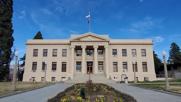
More recently, it was the setting of this artsy 2006 film by Daft Punk. Well the Militant got to walk the same streets as those dancing bears and those helmeted Frenchmen. This place was definitely full of history, like the 1922 Inyo County Courthouse (a.k.a. INYO COVNTY COVRTHOVSE), the 1927 Winnedumah Hotel, the northern sister of the Dow Villa (same founder and same celebrity guests BITD) and the Eastern California Museum (more on that later…).
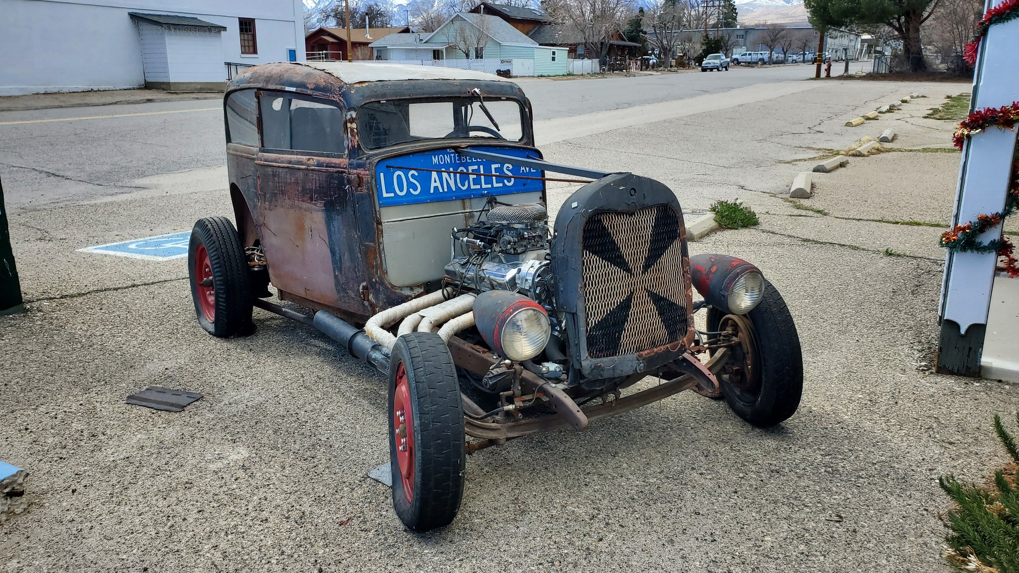
The historical aspect of Mini-Chillville makes it The Militant’s Kind Of Place in that regard, but…the place looks rather forlorn. When The Militant started his walk through town, he passed by an abandoned gas station. Then when he walked up to the Winnedumah, he discovered it was…not currently in business. He even saw a lovely restaurant with a rose garden and outdoor seating, but it was abandoned. One of the restaurants seen in the Pepsi Commercial and the Daft Punk film, also abandoned. Then there was another abandoned gas station. And another abandoned artsy storefront thing with an abandoned piano in front of it. But there were a couple of active gas stations, a French restaurant called Still Life Cafe, a couple taco trucks and a vintage/thrift store (still in business but closed for the day) that had an old-school hot rod that made The Militant feel at home:
The Militant walked on over down Center Street to the Eastern California Museum. Kewl, museum time! It was a small, single story building with exhibits on the history of the Owens Valley and surrounding environs. There was the requisite Los Angeles Aqueduct exhibit (entitled, “Building Bill’s Ditch”), a supplementary Manzanar exhibit, an display celebrating a mountaineer named Norman Clyde (who seemingly climbed half of the entire Sierra), willow baskets made by the indigenous Paiute-Shoshone people…and there was an outdoor display of vehicles and equipment used to built the Los Angeles Aqueduct…and there was an old-school steam locomotive (fully restored less than a decade ago), although it was resting in its little engine house…
Speaking of history, The Eastern California Museum in #IndependenceCA is WHERE IT’S AT! #LAAqueduct construction pics, Manzanar and willow baskets made by the area’s indigenous Paiute-Shoshone people.#OwensValley #EasternSierra #MilitantRoadTrip pic.twitter.com/eRtict0hwn
— Militant Angeleno (@militantangleno) March 7, 2024
…and just outside the museum building, there was a NATIVE PLANT GARDEN! YOOOOOO, WHAT IS THIS PLACE?!?!
Then, at the garden he heard the sound of rushing water in the distance. He saw a creek! He walked closer an closer to it and saw…no…experienced THIS:
It was like an extension of that same feeling he experienced at the Soul Consoling Tower at Manzanar, only even more magnified. It’s hard to explain. It’s like The Militant experienced true inner peace for the first time in his life…it sounds crazy…but the sound of the creek, the clear, cold water, the sight of the snowcapped Sierra Nevada mountains looming in the not-so distant background, the seemingly endless span of sagebrush carpeting the valley floor, and the interplay of waning sunlight, shadows and clouds hanging over the Sierra, which casts its own shadow some 15-20 miles across the valley on the face of the Inyo Mountains (All up Inyo face). The Militant had his own Double Rainbow All The Way Across The Sky kinda moment. Now he know what Yosemitebear62 (R.I.P.) felt like back in 2010.
The Militant walked back to Ray’s Den motel and chilled there the rest of the night subsiding on some Trader Joe’s food and the bottle of La Fin du Monde beer he also bought from TJs. He just wanted to simmer in that moment of inner peace that unexpectedly hit him by the creek outside of the Eastern California Museum. He was at peace here. No traffic. No smog. No ghetto birds circling the sky. Maybe he was meant to come here. Maybe the ghosts of history that The Militant inadvertently summons constantly wanted him to be here. Maybe. Maybe. Maybe.
The Militant may or may not have become a changed man today, in a place called Independence, a place that he never thought was actually real, but was realized today.
To be continued in Part 4: There It Is, Intake It!
You must be logged in to post a comment.